A Voyage to Aomori, Part 4 of 5
 |
| The Oirase River. |
 |
| Lake Towada. |
Many of Japan's most popular sites of nautral beauty are also
immensely destructive volcanoes. Indeed, that volcanism tends to be
precisely what made them so beautiful. This is something the millions
of people who flock there to take selfies and soak in hot springs
might do well to consider.
Hakone is perhaps the best example, but another may be found in the mountainous heart of Aomori Prefecture. At the centre of its southern border, Lake Towada (十和田湖) is a bright blue lake 11km across and almost perfectly circular. The lake, along with the upper course of the Oirase River (奥入瀬川) that flows from it, is now one of the major natural attractions of the Tohoku region, above all in the autumn when its crystalline blue and white currents are wreathed in flaming yellows and reds.
Hakone is perhaps the best example, but another may be found in the mountainous heart of Aomori Prefecture. At the centre of its southern border, Lake Towada (十和田湖) is a bright blue lake 11km across and almost perfectly circular. The lake, along with the upper course of the Oirase River (奥入瀬川) that flows from it, is now one of the major natural attractions of the Tohoku region, above all in the autumn when its crystalline blue and white currents are wreathed in flaming yellows and reds.

 |
| Aomori Prefecture, with Lake Towada at bottom centre. |
In
fact Lake Towada is a massive volcanic caldera, formed by six
major eruptions over the millennia.
It is considered active to this day, and though its eruptions are not
frequent, those that have happened have been spectacularly violent.
The most recent, in 915 CE (when
it was still not really part of Japan),
was one of the largest volcanic eruptions in Japan's recorded history
and smothered the entire region in ashfalls and pyroclastic flows.
 |
| Remarkable rock formations and colours, many more spectacular than this, can be found around the rim of the lake and attest to the dramatic processes that created it. |
The
photos that follow come from a walk along the upper Oirase River,
followed by a boat crossing of Lake Towada to the little town of
Yasumiya (休屋),
the lake's only settlement. The area can be reached in two to three
hours by a regular bus service
from Aomori City or Hachinohe, and with good planning can be explored
as a day visit. Note again that winter in this region is rough and sees
both the bus and ferry service suspended –
check before you go.
Oirase
Gorge (奥入瀬渓流)
Lake Towada drains east into the Oirase River, whose first 14km runs through a gorge of lush deciduous forests and rock formations. From there it flows on to irrigate the eastern towns of Towada, Rokunohe and Oirase (be aware, when choosing your bus, that the towns themselves are some distance away from Lake Towada and the Oirase Gorge), before finally disgorging into the Pacific Ocean just north of Hachinohe.
Aside from whatever it was like in Emishi times, for which the record is wanting, this area's rise to human significance is recent. It is thought to have been wilderness at least until the late Edo Period, when the Nanbu clan of Morioka Domain, who controlled this area, began using the Oirase River to irrigate their major land reclamation projects downstream.

Nowadays a road follows the full length of the gorge. The advantage
of this is that you can get on and off the bus at any stop along the
way, customising your walk or cycle to a length that best suits you.
The drawback is that the walking trail parallels the road and at
times crosses it, meaning that an immersive wilderness experience is
not what you will find here, least of all in the autumn peak season.
Even in the summer large tour groups may be regularly encountered,
most of whose members will be above a certain age, and these days
much Chinese will likely be heard.
On the other hand the traffic is not too bad outside of autumn, and the roaring of the rapids and waterfalls helps make the road and its consequences a lot less obtrusive.
On the other hand the traffic is not too bad outside of autumn, and the roaring of the rapids and waterfalls helps make the road and its consequences a lot less obtrusive.
 |
| Map of the Oirase Gorge. The key waypoints are Yakeyama (焼山) at the east end, and Nenokuchi (子ノ口) at the west where the river begins from Lake Towada. |
For
the full walk, get off the bus at Yakeyama
(焼山).
I actually started a couple of stops further down at Ishigedo
(石ヶ戸),
marked by the red hut icon on the map above. This is where the most
scenic section of the gorge begins, and you can reach the lake from
there in three to four hours of walking.

 |
| Ishigedo's namesake. The signboard reads: 'In this region's dialect, the “-gedo” from Ishigedo means a hut. Pairing it with “ishi”, which means stone, gives Ishigedo the literal meaning of a stone hut. However, in actuality, it is a large stone which has been propped up on one side by a giant Katsura tree, which gives the appearance of a stone hut. An ancient legend says the demon called O-matsu, a beautiful female thief, lived here and would steel valuables from passing travelers.' |
Many rock formations like this one line the gorge's length. Most have
accompanying stories, and if you pick up a map or leaflet you will
find each one marked out and named for you.
 |
| Notice the tour group on the left. In places the path is only wide enough for one person at a time, so yielding or waiting may be required. |


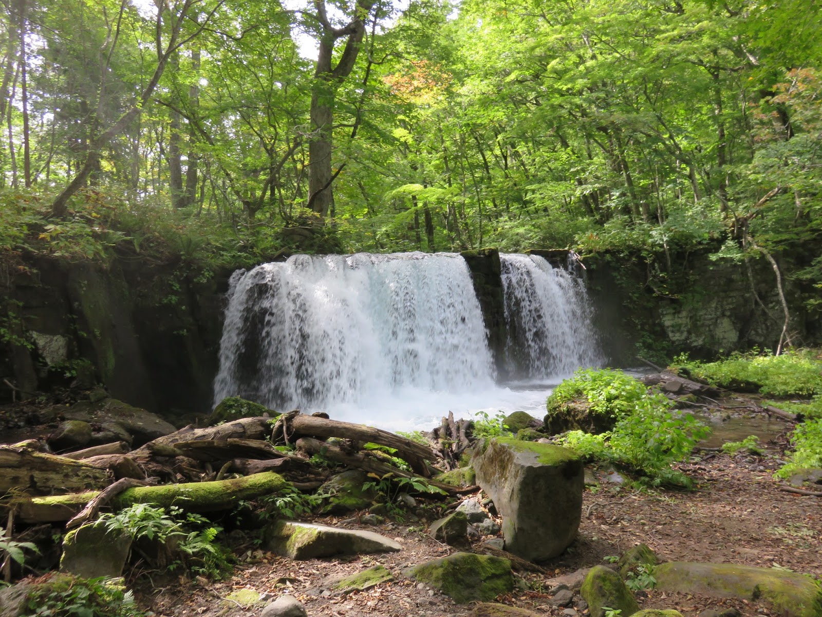
Another outstanding feature is the waterfalls, of which there are
over a dozen. These too each have their own names, shapes and
legends.
 |
| “Nine Steps Waterfall”. |

 |
| This one is near the end, on the main river course, and its significance is that fish cannot swim up it into the lake. More on that in a moment. |

Throughout it all there is the river itself, and the rich diversity
of the forest that surrounds it. Perhaps the images can speak for
themselves.


You might also spot animal life in these waters. I could not identify
these eel-like fellows, who went away once they noticed I was there.

Eventually
you emerge at Nenokuchi (子ノ口),
at the eastern shore of Lake Towada.


There
is a bus stop here, from where you can go back down the gorge or
return to the city. Or you can get on the ferry (website
with timetable here)
and cross to Yasumiya.
Lake Towada (十和田湖)
Lake Towada (十和田湖)
You are now
right on the border between Aomori and the northeast corner of Akita
Prefecture – indeed, the line cuts right down the middle of the
lake so the west half is in Akita and the east in Aomori. This is
good news if you are a fan of Akita kiritanpo,
as you will find it on sale from shops and vendors in this area,
including the little eateries here at Nenokuchi.
From the ferry, you can appreciate some of the lake's picturesque geology.
From the ferry, you can appreciate some of the lake's picturesque geology.


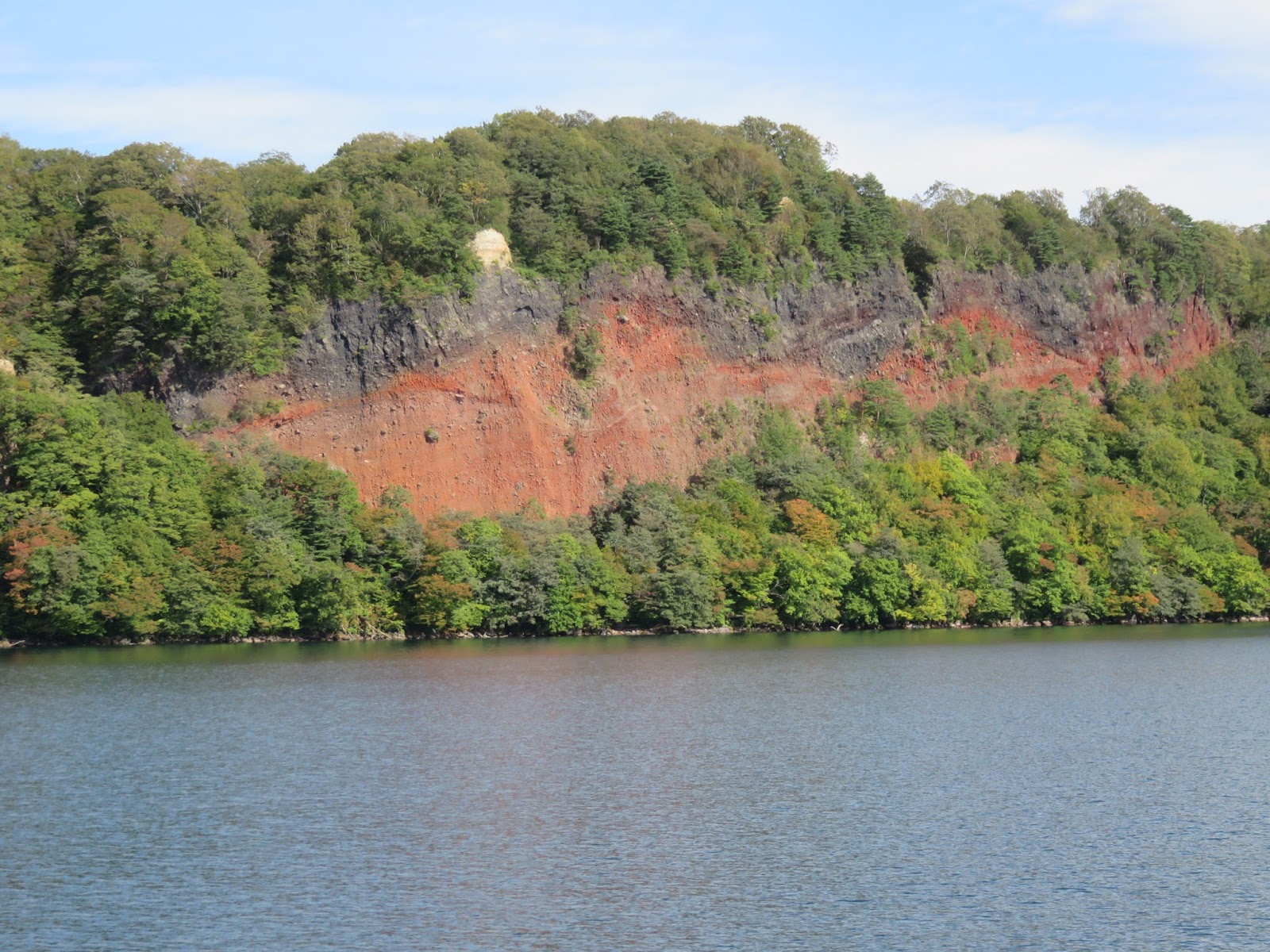

Two little peninsulas, the Nakayama and Ogura, jut out from the
lake's southern shore. These frame a cove which is itself another
caldera, known as the Nakanoumi caldera. This was created 53,000
years ago by one of Towada's more explosive eruptions.
The Ogura peninsula has a noticeable rounded bulge, though it does not appear in these photos. That, too, is a lava dome, created in fact by the 915 CE eruption that so devastated the surrounding area. None of that is all that long ago in geological terms, by the way. Just something to think about while you relax in the apparent peace of this place.
The Ogura peninsula has a noticeable rounded bulge, though it does not appear in these photos. That, too, is a lava dome, created in fact by the 915 CE eruption that so devastated the surrounding area. None of that is all that long ago in geological terms, by the way. Just something to think about while you relax in the apparent peace of this place.


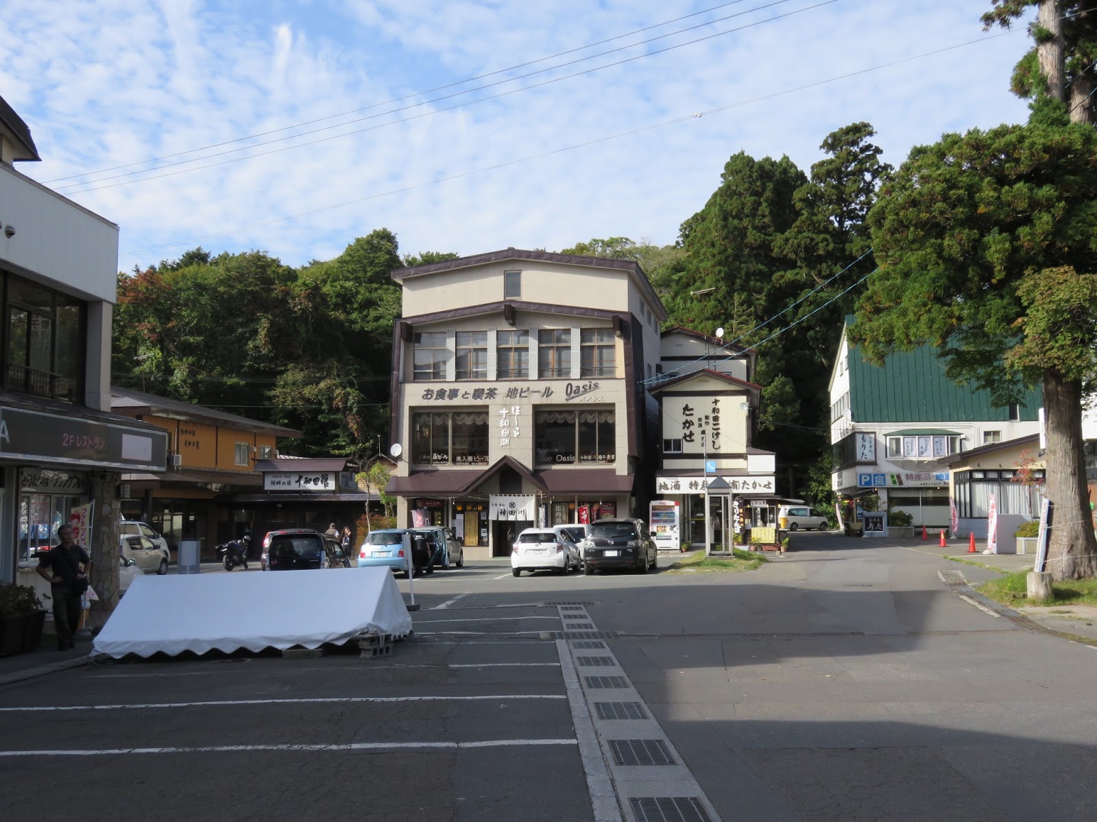
Within an hour the ferry approaches
Yasumiya (休屋),
the resort town on the lake's southwest corner.
 |
| Yasumiya, with Ebisu-Daikoku Island in the foreground. |

The central figure in the development of this area would appear to be
one Wainai Sadayuki (和井内貞行), who worked in the iron mines here in the
Meiji Period. Specifically he guarded the mines' water supply, a
capacity in which he noticed that there were no fish in the lake on
account of that insurmountable waterfall at the top of the Oirase
River.
In 1884, perhaps wanting to give the miners something better than dried fish from town to live on, Wainai introduced salmon to the lake and tried to create a fish hatchery. Local opinion and superstition was against him from the start. It was thought that the very mention of fish would enrage the lake god, a legend people in these parts had held to for over one thousand years.
One can only imagine the pressure then when the effort failed, followed by a whole succession of further attempts.

Nonetheless, Wainai persevered, to the point of selling off his own
belongings to fund more attempts when he ran out of capital. And in
1902, almost twenty years after he began, the plan succeeded.
With the survival of the trout fry he had introduced two years earlier, Wainai established his hatchery, conducted research, and introduced more new species of fish each year. A whole new fishing industry grew up around the flourishing diversity of fish species that inhabits Lake Towada to this day. Wainai built on these successes to establish a lakeside hotel in 1916, and to promote Lake Towada area both as a tourist destination and a place of natural beauty deserving protection. In part on account of these efforts, it at last received legal designation as a National Park in 1936.
That said, there were very few people there at the time of this late summer visit, and almost all of those were of relatively advanced age. I am told it becomes absolutely packed though once the autumn colours reach their height.
A stroll down the lakeside
promenade takes you to the Maidens Statue, the symbol of Yasumiya.
This bronze sculpture was built by the poet and sculptor Takamura
Kōtarō
in 1953, commemorating the 15th anniversary of Lake Towada's
designation as a National Park.


 |
| The Maidens Statue. |

Turn inland and you enter an area
of natural lakeside forest which houses the Towada Shrine, fronted by
a colonnade of cedar trees.

 |
| Towada Shrine. |

And if you head back west down
the town's main road, you come to an otherwise unassuming stream that
marks the boundary between Aomori Prefecture and the northeast corner
of Akita Prefecture.


This is not a large settlement,
and everything is in easy walking distance. Just up the road from
that bridge are the ferry piers and the visitor centre. The latter
has a science museum where you can find out more about the area's
life and folklore. Nearby you can also ride those swan-shaped pedal
boats you always get in places like this. And when you are ready to
get out, the buses back to Aomori City or Hachinohe leave from
nearby.

And this is the kind of landscape
you will ride through if you travel between Lake Towada and Aomori
City. The intervening space in the prefecture's centre, the dividing
line between the old Tsugaru and Nanbu territories, is dominated by
the Hakkoda Mountains, a splendid range of ancient volcanoes and lava
domes. Even from the bus you can take in wide-open scenes of their
marvellous shapes and colours: a sight so compelling that I decided,
if there was any chance of doing so, that I would head up to explore
them on the following day, my last in these northern lands.
The weather was ominous. On the night of my return from Lake Towada a serious typhoon was battering Hokkaido, with Aomori in line to get swept by the furious Siberian winds in its tail. Nonetheless, perhaps there was something of an inevitability to the climb that followed – an experience which culminated, after the trials and catharsis of the high winds, with some of the most awesome views I have beheld anywhere in the world.
More on that in the final article of this series.
Other articles in this
series:
1)
THE
SHIMOKITA PENINSULA
– A
Bridge Between Worlds2) OSOREZAN – Mount Fear
3) AOMORI CITY – Rassera, Rassera: The Story of the North
5) THE HAKKODA MOUNTAINS – The Wind Rages
No comments:
Post a Comment